Rio Dulce
(Sweet River) has its origin in Lake Izabal.
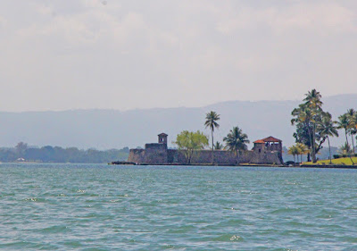
Shortly after it leaves the lake, it passes a small fortification,
Castillo San Felipe de Lara.
Built by
the Spanish to protect against pirates who came up the river from the
Caribbean, the fortress has a long and interesting history. A tower was built on the site in the mid 16th
century. The tower was destroyed in 1604
and the fortress was rebuilt in 1651.
Over time, the Castillo was used as a prison, severely damaged by
pirates many times and finally was completely reconstructed in 1955. The site is now a national park.
Shortly
after flowing past the Castillo, the river passes beneath one of the longest
bridges in Central America.
On one side
of the river is the small town of Fronteras, commonly known as Rio Dulce. The town is an important market city for the
area. Inhabitants of the surrounding
countryside come to its well stocked fruit and vegetable market. They come paddling Cayucos (dugout canoes) or in outboard powered lanchas. Large lanchas serve
as riverine buses, carrying workers and tourists to and fro.
The town also boasts numerous marinas
frequented by cruising sailboats from all over the world. Large numbers of boats, sail and power anchor
in the large bay.
On its way to
the ocean the river flows into a long, narrow lake, el Golfete. Ten miles long and a couple of miles wide,
the lake provides numerous inlets from creeks and quiet coves that provide
wonderful anchorages.
Fishing is
an important part of the local economy.
A statue was erected beneath the bridge in honor of the fisherman and
expresses the feeling of the local population.
As you travel along the river, you will see fishermen stringing seine
nets perhaps a couple of hundred feet long.
Others cast their purse nets from dugout canoes.
Along the
banks of the river are thatched roof homes built half on the shore and half on
stilts in the river.
Since there are no
roads, getting around requires boats and every home has at least one. Docks in front of the houses provide berth
for lanchas and Cayucos, even paddle boards.
Learning to handle boats starts at a young age. Public facilities such
as “Laundromats” require a long boat ride to Livingston or Fronteras. Riparian laundry facilities are conveniently
located right in front of the houses, in the river.
Shortly
after exiting el Golfete, the river passes through a spectacular gorge whose
cliffs tower 300 feet above the water.
The dense jungle on either side of the river is filled with teak,
mahogany and palm trees. It is home to
howler monkeys, a huge assortment of birds and flowers.
Twenty-seven
miles from its origin in Lake Izabal, Rio Dulce spills into the Caribbean
Sea. At the mouth of the river is the
unique town of Livingston. Standing on
the beach, you can see Belize just a few miles to the north and Honduras a bit
further to the south. Livingston is
accessible only by water and the town’s docks are filled with lanchas, dugouts,
and power boats. A sailboat or two may
be anchored just off shore. Like
Fronteras 27 miles away, it’s a busy town.
In a region where the only access to consumer goods is by water, it
provides the necessities of life. Like
other centers of commerce around the world, Livingston is home to haves and
have nots.
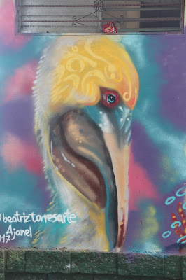
I was impressed by public
projects that encouraged the production of murals to beautify public spaces.
The town is
home to a Garifuna population. The
Garifunas are descendants of the Caribs and African slaves from the Caribbean
island of St Vincent. After being deported
to Roanoke off the coast of Honduras, they spread to Nicaragua, Honduras,
Guatemala and Belize on the mainland.
They have their own language based on Arawak with English and Spanish
mixed in. Their culture draws greatly on
their African heritage and is understandably different from the dominant Mayan
culture that surrounds them.


No comments:
Post a Comment